Crow Canyon Archaelogical CenterWashington State University


  Question 6      supporting material
 

Community Center Settlements in the VEP South Study Area
This map shows the locations of the largest sites in the VEP South study area, which we call community centers. Many of the large sites in this study area are also referred to as villages, but the biggest sites in the VEP South area grew so large they are sometimes called towns. The red dots are the smallest community centers, and our population estimates indicate these sites where home to 9–30 households, or 54–180 people. The yellow dots are medium-sized centers, which were home to 31–100 households, or 186–600 people. The blue dots are large centers and these were home to 100–200 households, or 600–1,200 people. The extra-large centers are shown as green dots, and these were home to 200–475 households, or 1,200–2,850 people.
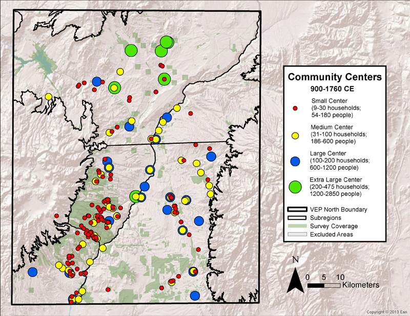
Map by Crow Canyon Archaeological Center (base map imagery by ESRI)


The Village Ecodynamics Project Major Partners


Our Mission
The mission of the Crow Canyon Archaeological Center is to advance and share knowledge of the human experience through archaeological research, education programs,and partnerships with American Indians.

Crow Canyon is a 501(c)(3) not-for-profit organization.


Copyright © 2015 by Crow Canyon Archaeological Center. All rights reserved.
Designed and maintained by Aztec Media Corp.

National Science Foundation Mesa Verde National Park Bandelier National Monument National Park Service Denver Museum of Nature & Science National Geographic U.S. Forest Service Santa Fe Institute Bureau of Land Management - BLM School for Advanced Research Wayne State University Colorado Office of Archaeology and Historic Preservation Canyon of the Ancients National Monument University of Windsor University of Norte Dame New Mexico Historic Preservation Division